
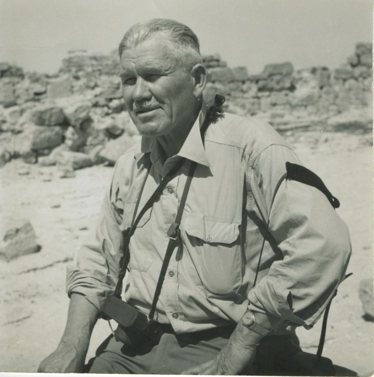
Walter Lowdermilk was recruited by Rexford Tugwell in 1933 to serve as the second-in-command of the new Soil Erosion Service, later called the Soil Conservation Service. In 1938, he was tasked with studying how the husbanding of soil affects human life and well-being. He spent two years exploring lands once ruled by the Romans to find answers. It is on this trip he evolves from scientist to prophet.
OBSERVATIONS ON FOOTPRINTS OF ROMAN AGRICULTURE
IN NORTH AFRICA
By:
W. C. Lowdermilk
Chief of Research
Soil Conservation Service
The onward rush of high speed agriculture in the United States and the rapid impoverishment and destruction of great areas of fertile lands has led conservationists to turn the pages of history for study of land use of older civilizations which have waxed and waned or disappeared, so as to profit by the experience of the past.
The most surprising revelation of a six months journey thus far across Europe and North Africa, has not been the huge land reclamation projects of the modern nations, admirable as they are, but the millions of acres of land in North Africa, despoiled and denuded by the hand of man and his herds, leaving only footprints of past glory upon the naked landscape.
These footprints of Roman occupation are sometimes indistinct or strewn about, or buried altogether. Others are still intact and useful, though overrun by centuries of time and marauding invaders. These footprints consist of buildings of great Roman cities and towns, some of them excavated or in the process of excavation; others still buried in the tombs of time where they have been covered by erosion from the land which formerly fed them; also great aqueducts, cisterns, wells, tunnels, terraces, paved roads, covered sewers, canals, grist mills, check dams for diverting or spreading waters, desilting basins and reservoirs, enumerable stone olive presses often in areas devoid of trees, and interestingly, one single section of old olive tree culture whose mammoth gnarled trees still grow in basins where the Romans had planted them at least 14 centuries ago.
For seven weeks our automobile has rolled its way across 6,500 miles of North Africa, including Algeria, Tunisia, Tripoli, Libya and Egypt. From oases to oases, past camel caravans, through herds of sheep and goats or past Bedouin Nomad tents or natives still living in villages under stone age conditions. We have watched the landscape change from covering of olive groves, vineyards and grain fields in fertile alluvial plains to the nakedness of desert pavement, rolling sand dunes or mountain slopes over-grazed and scoured down to their rocky skeletons. We have seen the terrific ravages of man’s abuse of the land over centuries of occupation side by side with great modern projects of reclamation, conservation and colonization. Native Berbers and Arabs have been and are being pushed economically into the already overcrowded hill and back country to give way to colonists which overflow from France and Italy into their colonies and protectorates in North Africa.
Across the centuries comes the warning from the older countries that civilizations rise or fall on their food supply; the conservation as well as protection of productive soil and water resources is vital. Erosion, both by wind and water is as great, if not a greater enemy to modern than to ancient civilizations because of the use of power which makes man more destructive in his exploitation of the land than ever before in human history.
The widespread occurrence of these ancient Roman ruins and their richness and magnificence which bespoke a prosperity and population exceeding many times that of today, first led observers to conclude that climate had changed for the worse since the Roman era. Thorough studies in recent times have found no evidence that climate has changed in any important degree since the Roman epoch and that the Romans enjoyed no more rainfall than the inhabitants of today. Locally, however, important changes of climate have occurred where lands have been denuded of forests and vegetation and subjected to erosion and the quick run-off of beneficent rainfall, resulting in desert like conditions.
One can read the landscape of these long inhabited lands and translate the story of centuries of continued abuse of soils which formerly maintained large and flourishing populations, but which can now supply meager sustenance to a fleeting and sparse population of Nomads. The phenomena of shifting soils is thus far the most significant finding of our observations. Soils of entire mountain and hill slopes have shifted from the rock foundations to expose the naked rock skeletons of the hills. Quantities of these fertile soils were carried out to the sea in numberless torrents which discolored the blue Mediterranean with their silt laden waters. A portion of these shifting soils came to rest on the valley floor or canyon bottoms, depositing sometimes to great depths. These form fertile soil oases in the otherwise barren countryside; but storm waters which rush off the barren slopes cut gullies into these remaining fertile soil oases.
The destruction of Roman civilization in North Africa began with a moral decay and decline in the midst of luxury, and led to the incursion of the Vandals. While the Byzantine occupation recovered, rebuilt and stabilized a part of the empire, it was only temporary. During the sixth and seventh centuries the Arabs swept over the land and destroyed Roman cities, Roman culture, Roman Agriculture, and even the traditions of agriculture. More than all else, they and their goats, set in motion the processes of erosion which have shifted the soils and transformed vast areas of formerly productive lands into desert like wastes of active erosion. The Arabs, descendants of Abraham through the line of Hagar and Ishmael, are frequently spoken of as “Sons of the Desert”, but it may be more apt to call them “The Fathers of Desert Lands”. They have primarily been a nomadic people, caring nothing for permanent homes and agriculture, but wandering about with their herds according to the dictates of drought or pasture and chopping down trees for firewood or burning them to increase forage for their flocks.
One cannot realize the destruction and transformation until one has seen the amazing grandeur and beauty of these Roman cities now being excavated from the erosion debris which buried them. The wreckage of the surrounding lands is even greater than the destruction of the cities. Cities can be rebuilt, but surrounding slopes are cut up with such labyrinths of writhing gullies that the original vegetations, former condition or use, cannot be determined.
One day, after traveling for thirty nine miles from Sousse over an empty, tawny landscape, paralleling an old Roman paved road, and passing only Bedouin Nomads and four small clusters of houses, not worthy to be called villages, we were startled to see a huge dark mass loom up on the horizon. It grew taller and wider as the miles vanished, and began to take clearer form. The light spots became windows and the jagged top and walls took the form of a huge coliseum with a circumference of 1200 feet and a seating capacity for 60,000 people. This mass of building stone and marble had been brought by boat nearly 2000 years ago, to the coast thirty one miles away and then carted overland to the populous and prosperous Roman city of Thydrus, famous for its vast olive cultivation. Now Nomad Marys were being followed around this great structure by wooly fat tail lambs, sheep and black goats as they foraged for meagre herbs, or ate the barbary cactus beside the road.
Our highway passed around the coliseum and over the great city of Thydrus, buried under the sands of the centuries. After destroying the city the Arabs used the coliseum as a fortress.
As is their custom, the Arabs soon destroyed the trees and orchards; the denuded lands began to blow. Wind erosion covered the city entirely, and partially filled the coliseum. Recent excavation revealed spacious thermae or public baths with gorgeous mosaic floors, still colorful and intact. Sand had preserved what the hand of man had failed to destroy. The outlines of a mammoth Roman circus or amphitheater, have been discovered but not yet excavated. A miserable village has been built above the old city, with stones which the Romans had so carefully carved and shaped into beauty, quarried from the upper ruins of the coliseum. This magnificent edifice no more resembles the present filthy village called El Djem, which has been hatched out as a brood from the mother stones, than does a peacock which has been deceived into hatching forth a brood of vulgar sparrows.
Around this region, as well as in countless other areas, sometimes treeless or with only an occasional olive tree as a remnant, we found great numbers of Roman olive presses of stone. French archaeologists have been of great assistance in determining the possibilities of reclamation based on former Roman land use due to these footprints left among the sands and soils of time.
In all our travels in North Africa we found only one remnant of Roman agriculture which was saved from Arab destruction. The Roman culture of olives persisted in the area around Sousse, and Tunisia, using the identical methods of enclosed basins and storm water irrigation. Also I suspect that these huge gnarled olive trees were planted by the Romans not less than fourteen centuries ago. No one knows how old they are. A rain of the winter gave us an opportunity to see how the Roman method of conservation of rain waters worked: how Arab farmers of today directed the storm water from basin to basin.
These ancient olive orchards are planted about 50 trees to the acre as against the spacing of 10 to 20 in the modern plantings. An earth bank surrounds each basin in which from four to ten trees are planted. These basins are level and set at different levels according to the topography. Thus each basin becomes a veritable reservoir which conserves all rain waters that fall, against the needs of the long dry summers. Furthermore, the water from the barren or closely grazed adjoining slopes is guided into the basins and as soon as one basin is filled, the farmer diverts the water to other basins in turn. This method has proved its efficiency through the centuries; it prevents loss of soil by both wind and water erosion and conserves the greatest possible amount of moisture for olive culture.
French archaeologists found in the region of Sfax numerous olive oil presses throughout the windswept plains, dotted by thorny shrubs which had accumulated the blowing soils, forming hummocks. On the basis of these findings experimental plantings of olive trees would again flourish in this region. During the past forty years several hundred thousand acres of olive orchards have been planted. Sfax is a thriving city built on the new olive industry. Modern olive presses have been established and one meets on the highway large trucks, loaded high with barrels of oil. However, one portion of this general area has been destroyed by such excessive labyrinths of gullies that its utility for any cultivation has gone forever.
There is one lamentable feature of all this modern planting. The trees have been planted in straight rows, up and down the slopes, regardless of topography. Already erosion has taken its toll of the new plantings. In places the surface of the orchard is covered with erosion or desert pavement. We saw gully erosion in action. The raging storm run-off was carrying away the soils as they cut numerous gullies through the orchards. In other places, sand dunes of considerable size were growing; evidence that both wind and water erosion is already a serious problem in this extensive project. This erosion problem might have been avoided if modern plantings had followed the old Roman method. In view of the fact that olive trees, when protected from man and his ax, often live many centuries, contour planting and erosion control methods are especially needed in this modern project. When I drew the attention of French agricultural officials to this erosion problem and the need of erosion control, they agreed with me. They were not sure if the French colonials could be induced to plant on contour instead of in straight rows up and down slopes. Contour plantings would be an improvement over the Roman basin method, to suit modern methods of cultivation.
The ruins of old Roman aqueducts, many hundred of miles of them, with their manifold arches, stretch like elevated bridges across parched thirsty landscapes. Roman towns and cities were always located to take advantage of nearby streams or springs, or even many miles distant, if aqueducts could be made to bring water supply by gravity flow to the city. Some of these aqueducts are magnificent works of engineering. If the city was large, more than one aqueduct and water supply was provided. These flowed constantly and emptied their waters into reservoirs for storage in or near the city. We found that running water into individual city houses was customary. Timgad, a city of 25,000 population had 22 public baths. Bathing was an elaborate ritual with the Romans and required large supplies of water. Public latrines were provided with sanitary flushing systems.
We were conducted to a recent excavation near Timgad. An inscription on a stone slab excavated at the sight of a reservoir revealed that the Roman Emperor had ordered the malarial marsh on one side of the city be drained. Tunnels were constructed of concrete, and the waters conducted through basins and into a reservoir to supply another public bath for the city.
We have found a number of instances where the Romans transported waters through underground tunnels to avoid evaporation. Also we found where they had dug several wells and connected them with communicating tunnels in order to increase the water supply by tapping larger areas of seepage and to prevent loss by evaporation during long dry spells. It was noted that inscriptions gave credit to this or that Emperor for aqueduct or irrigation projects, which shows the attention and importance placed upon the development and conservation of water supplies.
Roman footprints, in the form of cisterns, have been left by the thousands all over North Africa, extending from the coast far out into the desert on camel caravan routes. Many of these cisterns are now being used; others are being cleaned out and repaired. One is apt to find a cistern in any spot which gave promise for the accumulation of rain waters, whether for irrigation, village supply or for herds.
Cisterns are of all sizes, from small ones of a few gallons capacity to huge cisterns of 250,000 gallons. Many of these larger ones are provided with a desilting basin and a spillway. I visited one huge Roman cistern at Mergueb, 50 miles south of Tebessa, with a capacity of 210,000 gallons. It had been covered with a roof and repaired to supply water for herds. It is located on a long gently sloping outwash fan, on which were built low earthen banks to guide run-off waters, first into an 8 by 10 foot desilting basin and then into the cistern. The repaired spillway remained as the Romans had made it.
Last year a thunderstorm occurred in the vicinity and not only filled the cistern to capacity, but the spillway was of insufficient size and the waters overflowed the side walls. Thus run-off in the twentieth century exceeded the expectancy of Roman engineers. Whether this was from greater rains than in ancient times or caused by greater run-off from the present denuded soils, cannot be ascertained. While the evidence is not conclusive, it discounts the theory of the desiccation of North Africa since Roman times.
Underground water tables in the lowlands appear to be unchanged since Roman times. Roman wells, in the lowlands of widely separated areas, which have been cleaned out and repaired, give evidence that the water level today is almost identical with that two thousand years ago when the wells were dug and faced with stone.
The Romans were also masters in the art of stone or earth terracing. Whether this originated with them or with the ancient Phoenicians is not yet clear. But that they extensively practiced terracing for agriculture and olive groves is certain. South of Tebessa we found a system of check dams and terracing on the slopes facing the Sahara. One dam, long since broken, measured 110 feet on the crest and 12 feet in height. In the vicinity of Sbeitla is an elaborate system of check dams and terraces, extending up to the tops of the mountains for the culture of the olive and grains. These works were followed out to the valley floor where they still serve to aid the Arab in barley culture, though in a state of partial ruin. Perhaps the maximum development of terracing dating from Roman times is to be found in the Grand Atlas Mountains in Morocco where the slopes are terraced in elaborate detail by the Berbers.
We have seen numerous “karms” or artificial earthen mounds in the Northern Libyan region of Egypt, which contain many Roman ruins. These “karms” built in connection with enclosures, appear to have been constructed to add the run-off from their slopes to the gardens in the enclosed area. These enclosures are still in use for Arab barley fields.
Thus today, after fifteen to twenty centuries, we have found various footprints of Roman occupation in North Africa. We have seen her temples and gods; her coliseums where Romans gloated at human agony and death by torture, or wild beasts, or by methods which only depraved minds could conceive; her slave markets where human beings were bought and sold to labor, that Roman masters might live in luxury and leisure; her aqueducts and elaborate baths; her paved roads of commerce in areas sometimes now devoid of populations; her public works and remains of agricultural practices which were made of stone, and are still visible after centuries of marauding invaders. Cato wrote that if one wished to compliment a Roman, he should be spoken of as an “agriculturist”, but they were “gentlemen farmers” who studied the times and seasons and methods for planting, but ordered slaves to do the work. The extent to which they recognized the wastage of erosion is not known, but Roman footprints visible today reveal an extensive and detailed knowledge and practice in the control and use of little waters, and the conservation of soils. But we have also seen how all these measures and works can be destroyed by man until productive lands are transformed into man-made deserts — deserted except for Bedouin nomads and their herds.
/s/ W. C. Lowdermilk
Beirut, Syria
March 3, 1939
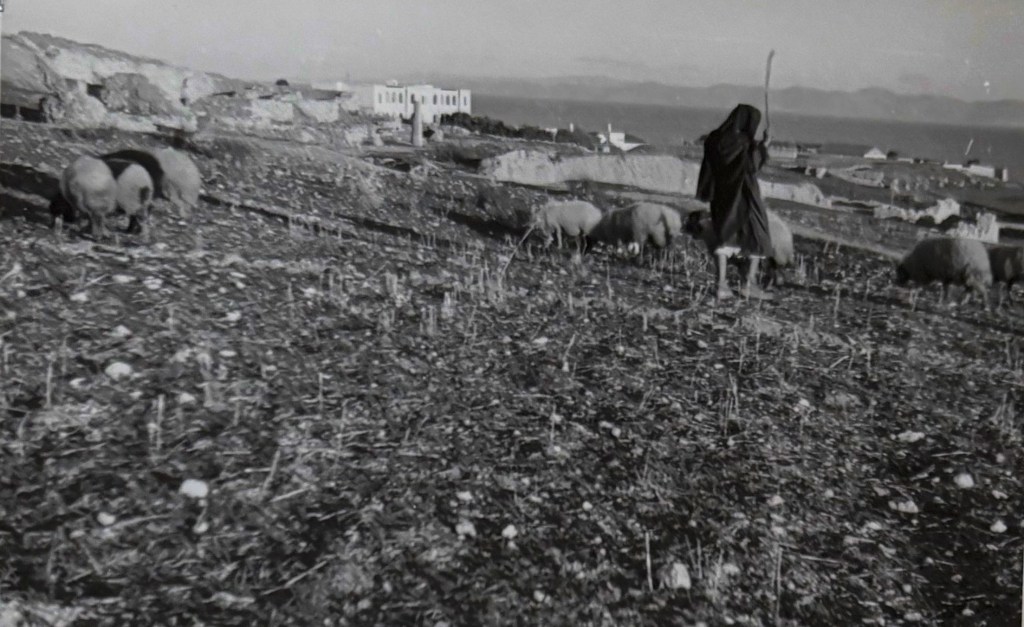
Carthage
Glories of old Carthage have sunk into the sepulchres of history. Modern homes were built on her crumbled stones and dust, but the nomad still herds his flocks over what was once the powerful city of Carthage.
Jan. 1, 1939. W.C.L.
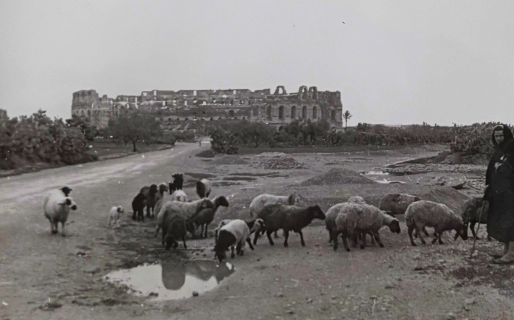
El Djem
View of the giant coliseum at El Djem, and a wretched village built on the covered ruins of the ancient Roman city of Thysdrus. The Coliseum seated 60,000 persons, which is many folds the entire population of the surrounding region today.
Feb. 5, 1939. W.C.L.
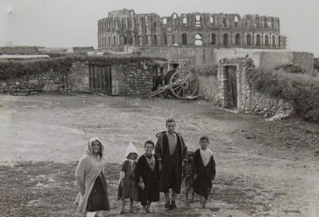
El Djem, Tunisia
Foreground of the 20th Century shacks and their inhabitants against the background of the great Roman Coliseum to seat 60,000 people. The great city is still unexcavated — only the coliseum towers above the buried city on which shacks have been built.
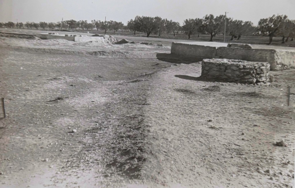
Roman well and cistern
Old Roman well and cistern now repaired and in use. Ancient stone olive presses found in this region by French Archaeologists led to the planting of about 200,000 acres of olives, North Africa. Feb. 1, 1939. W.C.L.
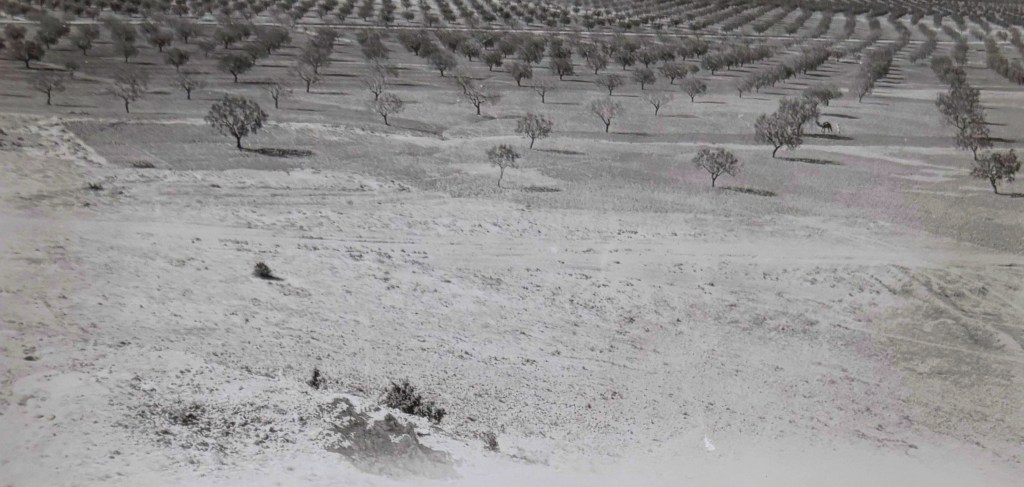
SFAX, TUNISIA
Recent plantations about Sfax, Tunisia, have been extended to 200,000 acres in the past 40 years. Prior to the recent plantings not an olive tree was to be found in the Sfax plain, where Bedouin nomads grazed their flocks seasonally. Archaeological evidence in oil presses indicated extensive culture without irrigation during Roman times. If the climate had not changed then olives should grow today. They were planted and thrived. But instead of following the ancient method of forming basins of earth mounds to hold all the water that falls and runs in from impluvia of barren slopes, the trees have been planted in straight rows and the land kept clean by fallow plowing to conserve moisture. An Arab is plowing with a camel in the right middle ground for this purpose. Straight rows have induced run-off of storm waters and gully erosion, which has caused serious damage in this area. Likewise a fallow condition of the land with trees spaced 10 – 20 to the acre invited wind erosion, which has already formed sand dunes in portions of this area.
Feb. 1, 1939. W.C.L.
Editorial Notes on Controversial or confusing Passages
As Richard Feynman said, “Science is a culture of doubt.” Lowdermilk shows little doubt on these pages. Whether the certainty comes from Inez’s influence or his progressive bent can be speculative only. Nonetheless, he is declarative almost prophetic in his report.
Lowdermilk refers to earthen runoff enclosures as “karms,” likely borrowing from the Arabic karm (vineyard or cultivated enclosure). The hydraulic features he describes are more accurately classified as meskat or related runoff-harvesting systems documented in North African agricultural literature. His terminology reflects the fluid transliteration and observational shorthand common in interwar field writing.
Statements attributing environmental degradation primarily to ‘the Arabs and their goats’ is too facile and reflect a common early 20th-century environmental determinist framework. Lowdermilk’s progressive worldview would emphasize centralized planning by technocratic experts. Modern scholarship recognizes land-use change in North Africa as the result of complex, multi-period processes involving Roman, Byzantine, Arab, Ottoman, and colonial regimes, as well as climatic variability and economic transformation.
The phrase ‘The Fathers of Desert Lands’ is polemical and reflects Lowdermilk’s bias toward experts and their ability to plan, finance, and build, rather than a balanced historical assessment. It should be read as an expression of his soil-conservation thesis rather than an ethnographic conclusion.
Descriptions of El Djem as a ‘filthy village’ and the peacock/sparrow metaphor reflect period language and colonial-era aesthetic judgment. Such phrasing is preserved here verbatim for documentary accuracy.
The claim that Roman civilization declined due to ‘moral decay’ echoes classical historiography and 19th-century moral interpretations of imperial collapse; contemporary historians emphasize political, economic, military, and ecological factors.
The discussion discounting ‘desiccation’ theories reflects interwar debates over climate change in North Africa. Current climatology suggests regional variability but does not support a simple desiccation narrative.

